
Explore
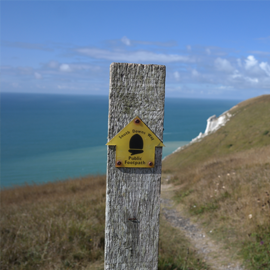
The South Downs Way
A designated National Trail, the South Downs Way attracts hundreds of thousands of visitors each year each looking to get a taste of the stunning South Downs National Park. Now is the time to indulge yourself in a little piece of the South Downs Way, whether by foot, wheel or hoof.


*This is an Amazon affiliate link that helps support our site.
The South Downs National Park
The South Downs National Park welcomes visitors from across the country, and the world to experience its natural wonder, far-reaching views and endless skies (on a good day of course!). The park is bountiful with many places to stay including hotels, bunkhouses, Bed and Breakfasts, campsites and even yurts and shepherds huts.
The provision of wonderful restaurants, cosy fireside pubs, rivers, seaside, hills, woods, walks and the transport links from London, Portsmouth, Southampton and beyond means this special part of the country consistently ranks as one of the most popular places to spend an afternoon, a day, a weekend or even a week!
Plan your Trip
Our comprehensive guide to the South Downs Way means that planning your trip has never been easier. Try using our intuitive route planning tools, transport, accommodation and activity sections, designed to help you make the most of your visit to the South Downs Way.
Plan your walk | Plan your ride | Plan your hackList of National Trails in the UK
- The Pennine Way – 268 miles (431 km) from Edale, Derbyshire through the Pennines to Kirk Yetholm, Scottish Borders.
- Offa’s Dyke Path – 177 miles (285 km) following the Welsh–English border from Sedbury Cliffs, Chepstow to Prestatyn, North Wales.
- The Thames Path – 184 miles (294 km) following the River Thames from Kemble in the Cotswolds to the Thames Barrier, London.
- Hadrian’s Wall Path – 84 miles (135 km) following the Roman wall from Bowness-on-Solway to Wallsend, Newcastle.
- The North Downs Way – 153 miles (246 km) from Farnham, Surrey across the North Downs to Dover, Kent.
- The Cotswold Way – 102 miles (164 km) along the escarpment from Chipping Campden to the city of Bath.
- The Ridgeway – An 87-mile track across southern England, often called Britain’s oldest road.
- The Cleveland Way – 109 miles (175 km) from Helmsley around the North York Moors and along the coast to Filey.